QGIS and the joy of maps at the FT
A fantastic inside look at how the FT design maps reminded me why QGIS might be worth a look if you're into mapping your data.
If you have a passing interest in mapping and data viz then you should really check out Steve Bernard's fascinating piece on how they design maps at the Financial times
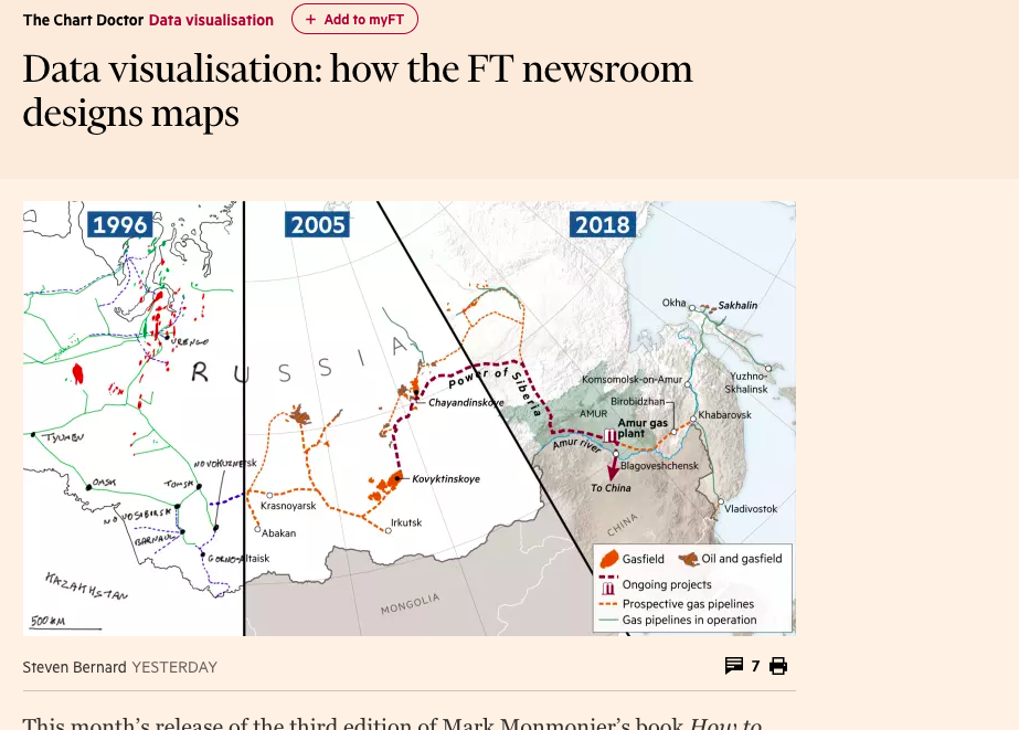
There's a tonne of insight into the process from the early days of tracing maps and scanning them, to creating "a script that will allow anyone to make maps entirely from the “command line” (the tool developers use to write code and run scripts)."
There's loads to get your teeth into in terms of ideas and jumping off points; In another tab I'm trying to get my head around 'Jenks natural breaks'.
The article also reminded me that if you have an interest in delving deeper into data and maps, you could do worse than spend a bit of time with free geo platform QGIS
GIS for journalists
Apps for mapping come in all shapes and sizes. More hardcore data journalists might even have mapping libraries in their R or Python toolkits. GIS or Geographic information systems, are at the more established end of the geographical data spectrum - and come with a lot technical baggage - but that doesn't mean they have to inaccessible. That's where QGIS comes in. It's a free way to open up your journalism and data exploration to some of that bigger GIS world.
I love tinkering with QGIS. In the past I've used it for finding the middle of somewhere . More recently I fired it up to create a file that would give me the new ward boundaries for local elections in Manchester. I've even used it to create 3d visulisations that can then be printed
I'll be honest, the learning curve is a little steep (well it was for me) and the pre-reqs for getting it to work (especially on a mac) could trip you up. But I think its worth the effort though (and the GIANTCAP approach works here).
I'd always start with a target ie."can I draw the electoral boundaries for my area on a map?" But if you want to have a go with QGIS and you're looking for something more general then these links may help...
- Steve Bernard has a stack of great QGIS tutorials on Youtube
- QGIS tutorials - Some good basic tutorials from Ujaval Gandhi (@spatialthoughts)
- QGIS basics for Journalists - the data has a US focus but this online course covers the basics really well.
- Mapping for Journalists - Data Journalist Maarten Lambrechts presents this free Learno course which includes a section on QGIS
- Mapping and QGIS for Journalists (and everyone else) - a neat roundup of introductory concepts around GIS
Enjoy tinkering.